
PhD Student Maciej Trzeciak, working under the supervision of Dr Ioannis Brilakis is devising an AI-based mobile scanner to digitise the geometry of existing infrastructure assets with high accuracy and density over longer distances. Top cameras and laser sensors funded by NRFIS are helping to achieve this goal.
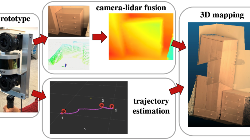
Image: AI-based 3D reconstruction from a mobile visual-laser system
Background
All engineering, architecture, and construction industries rely on spatial and visual data to inspect, operate and maintain existing infrastructure assets. For these industries, the digitisation of existing assets offers significant benefits, particularly in the increased efficiency of geometry and visual data collection. Yet construction is one of the least digitised sectors of our economy worldwide. It is estimated that improving digitisation in this area could significantly improve productivity, potentially creating up to $1.6 trillion of added-value - half the world's infrastructure need.
One of the key elements to improving digitisation within the infrastructure sector is the ability to accurately ‘map’, or otherwise create 3D scans of an environment using sensors such as a camera or a LiDAR (Light Detection and Ranging). For 3D scans to be suitably informative to the end user, they are dependent on highly accurate and dense surveys of the infrastructure scene with a mobile mapping device.
At present, current technologies are unable to accomplish middle-distance (10 - 50 meters) mobile mapping while maintaining the required density and accuracy for engineering surveys in near real-time. Here presents an opportunity to progress in this field.
Project – PointPix
Project PointPix aims to reduce the cost and time involved in digitising infrastructure assets by devising a mobile scanning system able to digitise the geometry of man-made structures with high accuracy and density while scanning over long distances. The project is sponsored by industry collaborators: BP, GeoSLAM, Laing O'Rourke, Topcon, and Trimble.
Engineering PhD Student Maciej Trzeciak is working under the supervision of Dr Ioannis Brilakis on this project to develop a prototype for a visual-laser mobile scanning system that is optimised explicitly for infrastructure scenes.
Using the facilities and equipment at NRFIS, Maciej’s research proposes to bring Artificial Intelligence (AI) to the process of collecting data and using it to accurately map infrastructure scenes over long distances.
“The visual-laser prototype under development utilises a combination of deep learning-based image-guided depth completion and visual-lidar odometry/SLAM to fuse high-resolution images from a camera and relatively lower-resolution 3D laser measurements from a LiDAR sensor” says Maciej.
“Guided by images from the camera, an artificial neural network predicts how to complete the gaps between the sparse LiDAR measurements to produce the required accuracy and density for the progressive construction of a 3D map.”
Initial Results
Initial tests of the prototype have shown the system to exceed the performance of currently available technologies for indoor scenes. Further research will be carried out to investigate the performance of the proposed method for outdoor middle-distance infrastructure scenes. A state-of-the-art mobile laser scanner will be used to accurately define and compare the current limits of the top technologies in the mobile mapping with the prototype development.
This project has been conducted using the equipment and facilities available in the Construction IT Laboratory at NRFIS. For more information on the visual-laser prototype being devised under this research, contact PhD candidate Maciej Trzeciak at mpt35@cam.ac.uk. Also, visit the website of the Construction Information Technology Laboratory at https://cit.eng.cam.ac.uk/.
The laboratory facilities at NRFIS are open and available to industry and all academic institutions and centres to support the delivery of interconnected, integrated, and interdisciplinary research for UK infrastructure. For further details about the equipment available at NRFIS, or to find out more about booking our facilities, please contact one of our NRFIS team members to discuss your project requirements.